Teaching resources
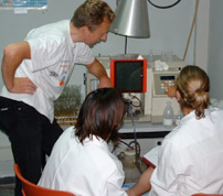
The Earth Sciences are predominantly a quantitative science, and the ability to properly analyse and interpret data is therefore a key requirement for Earth Science graduates. In this course we will explore how to analyse data and what statistical tools are available and appropriate to help in this analysis. We start with simple description of variables and how to compare data sets, then move to correlations between variables and regression modelling, before looking at more complex multi-dimensional statistical tools such as clustering, discrimination functions and principal component analysis. Finally visualisation of spatial data and interpolation techniques such as kriging will be addressed.
This course is tuned specifically to “geo” data, which include chemical data on rocks, soils and waters; size distribution of particles, minerals and fossils; and orientation of rocks in the field. This is because such data come with unique challenges that require dedicated statistical techniques. For example, we can unfortunately not run experiments on geological processes such as plate tectonics and will therefore always be limited by a small sample set.
The course consists of 2 hours of lectures and 3 hours of lab practicals.
A full course outline can be found here.
EPSC 552 (3 credits)
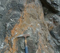
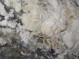
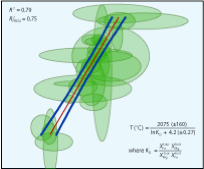
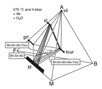
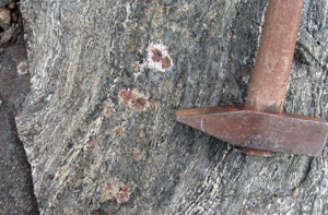
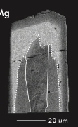
Metamorphic rocks are the most common rock type on Earth, and their study allows us to put constraints on the pressure, stress and temperature conditions in the crust and mantle, and on the composition in these environments. Metamorphism affects rocks in three ways; it changes their mineralogy, it changes their shape, and it can change their composition. In this course we will look at the processes behind metamorphism, description and classification of metamorphic rocks, and how to extract information from metamorphic rocks and minerals to determine the conditions under which they formed.
The course consists of 2 hours of lectures and 3 hours of lab practicals. The lab practicals will involve description and interpretation of hand specimens and thin sections of metamorphic rock suites and thermodynamic and geothermobarometric calculations to constrain conditions.
A full course outline can be found here.
Metamorphic Petrology
EPSC 445 (3 credits)
Geostatistics and Data Analysis
My teaching at McGill includes Metamorphic Petrology and Geostatistics and Data Analysis, as well as Ore Forming Processes and Fieldschool 2+3 in 2016. Information on these courses is provided here. If you would like more information, please come and see me in FDA 341, or send me an email.

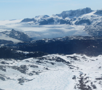
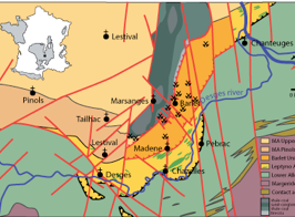
This fieldschool is an integrated geology, geochemistry and geophysics field course in the Massif Central Variscan belt in France. In a four week period, you will use mapping, structural analysis, geochemical surveying and exploration, and a variety of geophysical methods to understand the central part of this belt.
More information can be found here.
Massif Central Fieldschool
EPSC 331+341 (6 credits)
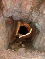
Ore deposits represent unusual enrichments of elements and compounds in or on the crust of the Earth. Understanding how these enrichments occurred requires information on the processes that operated and the conditions under which the elements were concentrated.
In this course we will explore various approaches to constraining conditions of ore formation, including temperature, pressure, RedOx potential, pH and fluid composition, in presentations and debates.
More information can be found here.
Ore Forming Processes
EPSC 561 (3 credits)
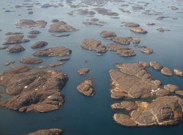
This virtual fieldschool explores the use of GIS tools, satellite images, aerial photographs and remote sensing data in remote mapping.
More information can be found here.
Virtual fieldschool 2
EPSC 331 (3 credits)
The Earth Sciences are predominantly a quantitative science, and the ability to properly analyse and interpret data is therefore a key requirement for Earth Science graduates. In this Geotop short course, we will explore how to analyse data and what statistical tools are available and appropriate to help in this analysis. We start with simple description of variables and how to compare data sets, then move to correlations between variables and regression modelling, before looking at more complex multi-dimensional statistical tools such as clustering, discrimination functions and principal component analysis. Finally visualisation of spatial data and interpolation techniques such as kriging will be addressed.
This course is tuned specifically to “geo” data, which include chemical data on rocks, soils and waters; size distribution of particles, minerals and fossils; and timeseries. This is because such data come with unique challenges that require dedicated statistical techniques. For example, we can unfortunately not run experiments on geological processes such as plate tectonics and will therefore always be limited by a small sample set.
The short course consists of 6 days with 4 hours of lectures and 3 hours of lab practicals each.
A full course outline can be found here.
Geotop Short Course in Geostatistics
EPSC 552 (3 credits)