Get in the spirit, this video actually touches on overthrusting and subduction, melt generation and collision:
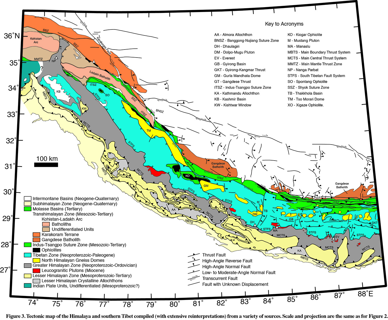
Orange batholith rocks correspond to arcs active just before and during the
final closure of the Tethys and early stages of Indian Collision. They lie
on or near the former edge of the Eurasian Plate during early collision.
Pink/tan belt is a Cretaceous-aged island arc with batholith complex (pink:
Kohistan and Ladakh Batholiths) and older basement/country rock (tan) into which
the arc intruded. This was the last terrane to accrete to Eurasia before India
collided.
Bright green with black spots: Accretionary complexes (green) with ophiolites
(black). Some are in place along the suture zone (ITSZ in the SE corner of
the map) while other outcrops are fragments of klippe which were thrust over
the Tibetan Zone marine seds (aqua)- for example KO (center of map).
Also shown in green are basins filled with molasse (molasse = sedimentary
detritus of a tectonic uplift, usually coarse grained, can be marine or
continental in depositional environment). In some areas, the transition from
marine to continental sedimentation is preserved in these basins (24-17 Ma).
The aqua belt is the Tibetan Zone, the continental margin sediments deposited
on the northern margin of India from the Cambrian to the Eocene. The section
is thought to be nearly complete. The section records periods of Paleozoic and
Mesozoic tectonism in India, and Permian rift basalts associated with Gondwana
rifting. Regional unconformities within the Cretaceous section are associated
with increasing tectonic influence before the Tethys closure. Terrestrial seds
appear in Eocene marking collision.
Yellow: North Himalayan Gneiss Domes. These are high-grade equivalents of
Tibetan zone sediments, uplifted on low angle normal faults. Some are cored
by young granites (18-10 Ma), implying dome formation during Miocene.
SOUTHERN TIBETAN DETACHMENT
Dark gray: The Greater Himalayan Zone - high grade metasedimentary and
meta-igneous rocks, with associated plutons (red). Separated from Tibetan Zone
by a giant extensional detachment (Southern Tibetan Fault System). Amphibolite
to migmatite meta seds and volcanics with a weird granitic layer continuous
near the top of the section for 100s km along strike. NB: some of the eclogitic
rocks show evidence for subduction and exhumation to >100 km depth. The plutons
(red) are thought to be derived from the migmatites in the metamorphic sequence.
MAIN CENTRAL THRUST SYSTEM
Light yellow: Lesser Himalayan zone - low greenschist to low amphibolte
metasediments, classic fold-thrust belt, retrodeformable/balanced cross
sections have been done in several places.
Light gray: Lesser Himalayan Crystalline - discontinuous belt of medium-grade
metasediments, granites and granitic gneisses within the LHZ.
MAIN BOUNDARY THRUST SYSTEM
Light yellow - Subhimalayan zone - modern molasse.
KEY TIMING OF EVENTS:
Here is a singly vergent wedge: Video at the bottom of the
page shows a sandbox experiment of a single-sided wedge with steepening of
older structures (folds and faults) as the wedge builds outward toward the
foreland. Sad Haaq, Purdue University
Banerjee and Burgmann (2002) GRL
Gervais et al (2010) J. Struct. Geol.
Recent GPS studies show significant crustal shortening in the southern 100 km
across the frontal thrust (estimated elastic strain corresponding to a slip
deficit of about 14 mm/yr; Banerjee and Burgmann 2002). Additional convergence
is accommodated by the strike slip faults along the edges of the Tibetan
Plateau, including at least 11 mm/yr on the Karakoram Fault. 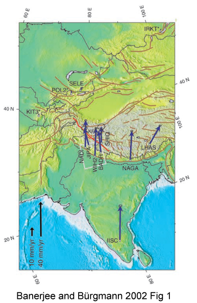
Below: Hodges (2000) summary map of the geology of the west-central Himalaya.
The rocks are roughly grouped as follows, from north to south:
Cretaceous (to 75 Ma) south-vergent folding and faulting associated with
ophiolite emplacement
At 54-50 Ma, sedimentation shifted from marine to subaerial along the
suture zone. Direct dating of the deformation associated with the suture is
not conclusive but seems to young to the east.
High P metamorphic rocks in the GHZ give metamorphic ages ~ 50 Ma, if these
are the leading edge of the Indian continent this represents date soon after
subduction of the leading edge
Story is complicated because exhumation has not been explained, but biotite
cooling geochron suggest T<300 by about 30 Ma, so uplift soon after
subduction, perhaps facilitated by doming.
Cross section balancing shows 100-200 km shortening in the Tibetan zone since
50 Ma.
Miocene - initiation of Main Central Thrust (still active)
Last 20 My - activity on both So. Tibetan Detachment and the Main Central Thrust -
basically exhuming the Greater Himalaya.
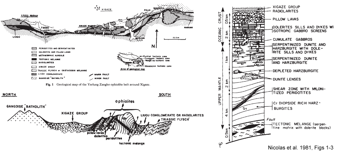
This 1981 paper by Nicolas et al. documents a structural transect across one of
the best exposed ophiolites of the Indus-Tsangpo Suture Zone: the Xigaze
Ophiolite. The major ophiolitic lithologies are well represented in stratigraphic
order, and the opihiolite is overlain by turbidite forearc sequence. The base
is sheared over Mesozoic turbidites/flysch affiliated with the Indian sub-
continent. These turbidite sequences include huge slide blocks, some up to
km wide, of Tethyan (Mesozoic) carbonates and shallow water marine rocks (Hodges, 2000).
And here's a video showing the large scale deformation during collision.
Key things to note: the development of curved to N-S strike slip fault
through the Syntaxes on both sides of the collision zone, also -
the block uplift of the Tibetan Plateau and foreland advancement of the
Himalayan fold-thrust belt.
Sandbox models have been used to investigate fault geometry and strain partitioning
in orogenic wedges. These models have the disadvantage of only incorporating
one type of rheology (frictional) but they have the advantage in that the
strength of materials and of basal contacts can be varied, and material can be
removed from the top in between deformation steps to simulate erosion. Here,
Malavieille (2010) summarizes a number of sandbox experiments to show the
structural developments of different types of wedges.
The internet provides many videos of such experiments.
Here is a doubly vergent wedge:
Here is a wedge with erosion removing the uplifted material - note the
significant difference in fault geometry!!
Models based on the physics of critical sand wedges are sometimes used (at
least on the broad scale) to describe even the viscous parts of orogenic belts.
Gervais et al. (2011) compared 3 models for how to get lower crustal rocks (dark
gray) into outcrop in the orogenic wedge, in between lower-grade rocks. The
top model (A) is based on the sandbox experiments of Malavieille (above). The
center model (B) utilizes a low-viscosity, melt-rich rheology in lower-crustal
rocks so they flow up the detachment. The third model (C) invokes buoyant
uplift and doming during extension.
Channel-flow models for melt-present lower crustal exhumation through dipping
shear channels have been applied to other orogens, including the Canadian
Cordillera:
Sources